
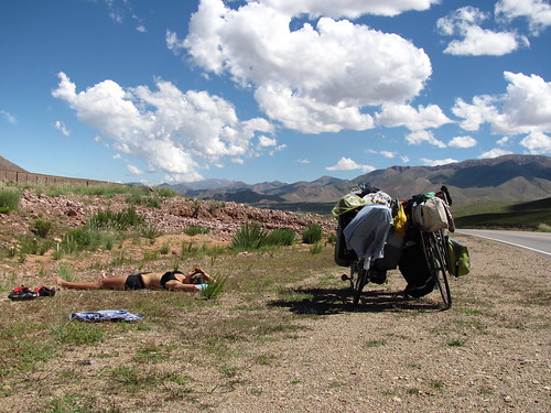
We continued to travel north from Salta on Route 9. The road here was much less trafficked than the road north from Tucuman and much more beautiful. We wound our way up a few hundred meters the first day and camped at a lake for the evening. Courtney washed clothes and we both bathed in the shallow water before bed. The bottom of the lake was covered in grass and the water was warm. The temperature was quite a surprise considering we were ascending the Andes and had already reached about 1500m - we were thinking the lake would be cold glacier melt, like most mountain lakes in the US. There are no glaciers this far north, the lake was most likely engorged with rainwater, explaining the grassy bottom. Day 2 we cruzed down down down to Jujuy through beautiful mountain switchbacks, stopping around every third bend for another perfect photo opportunity.
After crossing the dams south of El Carmen we decided to look for a place to camp but despite the complete lack of traffic for 2 days of travel, cars came out of nowhere and we were suddenly in the suburbs of Jujuy. Land was fenced off, the cars were loud and a place to camp was no where to be found. We decided to bike into town and camp at the gas station but getting there was not easy. 3 highways converge right at the south end of Jujuy making our entrance rather tricky.
We made it to the YPF and camped. In the morning we ran errands and eventually biked out of town. The man at the hardware store where we bought feul said "Van por el norte? mucho subiendo y bajando" "going north? lots of up and down" We also met a pair of Belgians - Paul and Coline who are traveling in tandem in the same direction as us. We only made it 35 km for the day before reaching our 1000 mile mark for the trip (US portion included)!!! We were very excited, stopped, took a picture, biked one more mile and decided we were done for the day. Some days are better than others for distance. A normal day we´ll make at least 50 km.

From our campsite just outside of Jujuy at 1500m we climbed for 3 days up to the top of the pass and into the Altiplano just past Tres Cruces with an altitude of 3700m. As it turns out there´s a lot more subiendo than bajando. Almost no bajando actually. We had been climbing since Tucuman (300m altitude) but much more gradually.
After lunch on the first day we were just starting to see the first signs of rain, and the wind was rushing us northward (better than trying to turn us around). We turned a corner, however, and were suddenly in the desert. The sky cleared, the hills turned into cliffs and the vegitation was suddenly prickily. Again, we stopped at every curve to take pictures.

We got to make some fun touristy stops along the way. In Pumamarca we saw the cerro de siete colores which is a mountain side rich with layers of rock from different epochs dating back to when the Andes were in the ocean. This mountain scene was worth the 3 km we biked out of our way, but also not uncommon along the route. Everywhere we looked the mountains revealed beautiful juxtaposition of color and form. On our way out of town we ran into the Belgian couple just heading in to camp for the night.
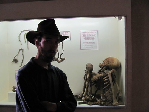
We camped outside of Posta de Hornillos - under a tree that seemed comfortable until we realized it too was covered in 2 inch pricks - so we could see the museum there first thing in the morning. The posta was one of many stops along a route from the silver and mineral mines in Bolivia and Peru on the way to Buenos Aires. Jujuy is one of the main hubs but the colonists had to try three times to create a station there. The indigenous groups resisted and destroyed the first 2. The museum showed a map of every battle fought between the indigenous people and the colonists. Between 1814 and 1824 (for the most part) the resistence was great but eventually, as we now can see, the colonists won out. The museum also showed a collection of archeological pots, tools, and even a mummy.

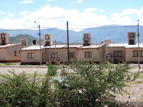
After Posta de Hornillos we wound our way up to Tilcara where we stopped to gather food supplies. The Municipal Market there is absolutely amazing. Beautiful vegetables and Courtney was even able to find a pair of socks for 2.5 pesos AR. Most of the larger towns along the route had mercados municipales. There is really no better way to shop. After lunch we made our way to Humahuaca where we stayed for the night. There we met up with the Begians once again. We camped together and have been crossing paths or riding together ever since.


North of Humahuaca we worked hard to accomplish our goal of Tres Cruces for the night. There is less oxygen after about 3000m so our last day was our hardest. We would also climb the 700m in one day as opposed to the 500m the previous two. We were also going farther than we had been. The road was steep and the wind was against us for the most part but the views were the most rewarding. We were still 20 km outside of Tres Cruces at 6:30pm. We had just decided we weren´t going to make it unless something spectacular happened when the wind died down and the road leveled out. We picked up speed and made the last 20 km in 1.5 hours. Paul and Coline were there waiting for us and making bets about when we would arrive.

From Tres Cruces we flew the next 80km to Pumahuasi. The Altiplano is just what it says it is. High and flat. We stopped in Abra Pampa for lunch - again there was a mercado municipal which treated us well. In the plaza we met up with Paul and Coline who noticed a US and Austrailian pair of cyclists coming from the north. They were helpful and friendly. We exchanged information about the southern routes for information about Bolivia. Only a few meters down the road we were landed upon by a group of touring cyclists from Columbia - traveling as 17 cyclists, all together - who told us that despite the fact that Uyuni is underwater, we had to go. So here we are in Tupiza, on our way.
La Quiaca is the Argentine border town. Together with Paul, Coline, we all road early in the morning to cross over to Bolivia. We split up because, being Belgian, they didn´t need to find a bank to pay the visa fee. We then proceeded to spend 3 hours in line crossing the boarder. If you make it here, you should know that they only accept US dollars, despite the fact that we are nowhere near the US. We had to change money 3 times and work through the beaurocracy. Then we rushed to the train station in Villazon - the Bolivian boarder town - and worked our way through another few lines to buy tickets, get our bikes unloaded and then pay for the luggage. We have been told by many many people that this particular section of road is the worst in all of Bolivia so the general concensus among bicyclists is to take the very affordable train ($3 US per person).
Here we are in Tupiza, a third of the way to Uyuni, a pit stop. We´re planning on hiking a bit and hoping that magically the salt flats will dry up and we will be able to bike them. As of now, however they´re under a meter of water. fingers crossed.
After crossing the dams south of El Carmen we decided to look for a place to camp but despite the complete lack of traffic for 2 days of travel, cars came out of nowhere and we were suddenly in the suburbs of Jujuy. Land was fenced off, the cars were loud and a place to camp was no where to be found. We decided to bike into town and camp at the gas station but getting there was not easy. 3 highways converge right at the south end of Jujuy making our entrance rather tricky.
We made it to the YPF and camped. In the morning we ran errands and eventually biked out of town. The man at the hardware store where we bought feul said "Van por el norte? mucho subiendo y bajando" "going north? lots of up and down" We also met a pair of Belgians - Paul and Coline who are traveling in tandem in the same direction as us. We only made it 35 km for the day before reaching our 1000 mile mark for the trip (US portion included)!!! We were very excited, stopped, took a picture, biked one more mile and decided we were done for the day. Some days are better than others for distance. A normal day we´ll make at least 50 km.

From our campsite just outside of Jujuy at 1500m we climbed for 3 days up to the top of the pass and into the Altiplano just past Tres Cruces with an altitude of 3700m. As it turns out there´s a lot more subiendo than bajando. Almost no bajando actually. We had been climbing since Tucuman (300m altitude) but much more gradually.
After lunch on the first day we were just starting to see the first signs of rain, and the wind was rushing us northward (better than trying to turn us around). We turned a corner, however, and were suddenly in the desert. The sky cleared, the hills turned into cliffs and the vegitation was suddenly prickily. Again, we stopped at every curve to take pictures.
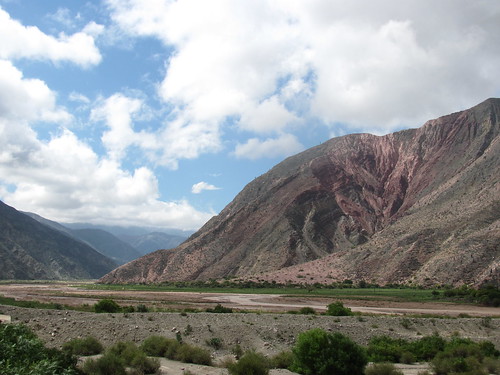
We got to make some fun touristy stops along the way. In Pumamarca we saw the cerro de siete colores which is a mountain side rich with layers of rock from different epochs dating back to when the Andes were in the ocean. This mountain scene was worth the 3 km we biked out of our way, but also not uncommon along the route. Everywhere we looked the mountains revealed beautiful juxtaposition of color and form. On our way out of town we ran into the Belgian couple just heading in to camp for the night.
We camped outside of Posta de Hornillos - under a tree that seemed comfortable until we realized it too was covered in 2 inch pricks - so we could see the museum there first thing in the morning. The posta was one of many stops along a route from the silver and mineral mines in Bolivia and Peru on the way to Buenos Aires. Jujuy is one of the main hubs but the colonists had to try three times to create a station there. The indigenous groups resisted and destroyed the first 2. The museum showed a map of every battle fought between the indigenous people and the colonists. Between 1814 and 1824 (for the most part) the resistence was great but eventually, as we now can see, the colonists won out. The museum also showed a collection of archeological pots, tools, and even a mummy.
After Posta de Hornillos we wound our way up to Tilcara where we stopped to gather food supplies. The Municipal Market there is absolutely amazing. Beautiful vegetables and Courtney was even able to find a pair of socks for 2.5 pesos AR. Most of the larger towns along the route had mercados municipales. There is really no better way to shop. After lunch we made our way to Humahuaca where we stayed for the night. There we met up with the Begians once again. We camped together and have been crossing paths or riding together ever since.
North of Humahuaca we worked hard to accomplish our goal of Tres Cruces for the night. There is less oxygen after about 3000m so our last day was our hardest. We would also climb the 700m in one day as opposed to the 500m the previous two. We were also going farther than we had been. The road was steep and the wind was against us for the most part but the views were the most rewarding. We were still 20 km outside of Tres Cruces at 6:30pm. We had just decided we weren´t going to make it unless something spectacular happened when the wind died down and the road leveled out. We picked up speed and made the last 20 km in 1.5 hours. Paul and Coline were there waiting for us and making bets about when we would arrive.

From Tres Cruces we flew the next 80km to Pumahuasi. The Altiplano is just what it says it is. High and flat. We stopped in Abra Pampa for lunch - again there was a mercado municipal which treated us well. In the plaza we met up with Paul and Coline who noticed a US and Austrailian pair of cyclists coming from the north. They were helpful and friendly. We exchanged information about the southern routes for information about Bolivia. Only a few meters down the road we were landed upon by a group of touring cyclists from Columbia - traveling as 17 cyclists, all together - who told us that despite the fact that Uyuni is underwater, we had to go. So here we are in Tupiza, on our way.
La Quiaca is the Argentine border town. Together with Paul, Coline, we all road early in the morning to cross over to Bolivia. We split up because, being Belgian, they didn´t need to find a bank to pay the visa fee. We then proceeded to spend 3 hours in line crossing the boarder. If you make it here, you should know that they only accept US dollars, despite the fact that we are nowhere near the US. We had to change money 3 times and work through the beaurocracy. Then we rushed to the train station in Villazon - the Bolivian boarder town - and worked our way through another few lines to buy tickets, get our bikes unloaded and then pay for the luggage. We have been told by many many people that this particular section of road is the worst in all of Bolivia so the general concensus among bicyclists is to take the very affordable train ($3 US per person).
Here we are in Tupiza, a third of the way to Uyuni, a pit stop. We´re planning on hiking a bit and hoping that magically the salt flats will dry up and we will be able to bike them. As of now, however they´re under a meter of water. fingers crossed.

No comments:
Post a Comment